Requires Javascript
Expect a few problems with vanilla X-Plane 11. Most of the time when I tried to find answers online, I either found nothing, or it was someone asking or help, but not getting a reply. The Discord wasn't all too helpful either.
Toggle Servosin the settings
Maybe this happened, because I don't have a full cockpit, but only a humble Logitech Extreme 3D joystick. I had to increase RPM extremely, when I wanted to go around curves. Overall, I had to go scary fast on the taxiways to get around in a controlled manner.
Solution: Assign a key to Toggle Nose Wheel Steering
so you can turn it off.
(forums.x-plane.org)
My Sim-PC has bad audio drivers and the microphone doesn't work. A mike is pretty important
for VATSIM, so I wanted to use X-Pilot on another machine (Mike-PC)
which can hear me, and this was easy to achieve:
Edit the file ...\X-Plane 11
on Sim-PC and change UseTcpSocket from false to true.
Install X-Pilot on Mike-PC (no CLD download needed), use
.simip <IP address of Sim-PC> in X-Pilot and connect.
| Livery | ...\X-Plane 11 |
Edit with GIMP, export to PNG, convert to DDS with |
|---|---|---|
| Cockpit | ...\X-Plane 11 |
Edit with GIMP, export to PNG, convert to DDS with |
| ATC (audio) | ...\X-Plane 11 |
Edit with Notepad, change acf/_tailnum |
| Related post | https://forums.x-plane.org/index.php?/forums/topic/122334-changing-tail-number-in-cockpit-eg-n172sp/ | |
Although not being a strict requirement, you'll want to fly on VATSIM using current navigation data (Airports, procedures, etc.).
There are paid subscription services that offer this data with worldwide coverage, but the FAA provides
free navdata for North America.
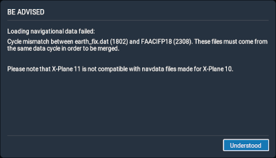
After downloading and installing the file, I got an error message about a cycle mismatch
and X-Plane terminated:

After some digging,
I found out about a global replace
method, by simply renaming the file FAACIFP18 to earth_424.dat.
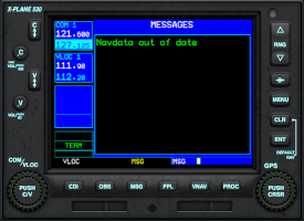
The cycle mismatch message stopped appearing, but the G530 navigation computer was still unhappy:

Effective Date
The FAA web site offered 2 links, and I downloaded the most recent file.
A friendly person on Discord told me to open it in Notepad and check the timestamp.
It turned out, that I downloaded a version that is not yet valid.
So I got the other file, verified that its EFFECTIVE time period is valid and reinstalled it.
Finally, the out-of-date message was gone.
FAACIFP18 from the .zip archive
earth_424.dat
...\X-Plane 11\Custom Data\
Beware, European data seem to change. I was missing ILS and VORDMEs after I installed the FAA data.
| xptools | Includes a PNG to DDS converter | x-plane.com |
|---|---|---|
| Free NavData | North America only | www.faa.gov |
| LOXT_Approach_RNP RWY08 | RNP RWY08 |
| LOXT_Approach_Visual Approach | LOXT_Approach_Visual Approach |
| Ground Overview | Ground Overview |
| LOXT_AIP | Luftfahrthandbuch |
| VFR | VFR Chart |
| Free Pilot Training | 10 Tips To Improve Your Landings | Cessna 172 and Others | YouTube |
| 74 Gear | Real ATC communication, safety and other topics | YouTube RSS |
| VASAviation | Real ATC communication | YouTube RSS |
| Mentour Pilot | Aviation procedures, accidents, incidents | YouTube RSS |
| Mentour Now! | Industry issues, new and emerging technologies, new aircraft, reaction videos | YouTube RSS |
| AP | Autopilot | ||
| ADF | Automatic Direction Finder | ||
| ASL | Above Sea Level | ||
| ATC | Air Traffic Contol | ||
| ATIS | |||
| CAS | Calibrated airspeed | Indicated airspeed adjusted for pitot system position and installation error | CRS | Course is the intended path over the ground, which is not necessarily identical to the heading of the craft | flightsim.com |
| DME | Distance Measuring Equipment | Usually combined with a VOR ("VOR/DME") | Wikipedia |
| EAS | Equivalent Airspeed | Calibrated airspeed adjusted for compressibility effects | |
| FAA | Federal Aviation Administration | Largest transportation agency of the U.S. government and regulates all aspects of civil aviation in the country as well as over surrounding international waters | Wikipedia |
| FD | Flight Director | Navigational aid that is overlaid on the attitude indicator that shows the pilot of an aircraft the attitude required to follow a certain trajectory | Wikipedia |
| FL | Flight Level | Altitude given in units of 100 ft, used above 18000 ft (FL180, U.S.) or above 6000 ft (FL60, UK) | Wikipedia |
| FIR | |||
| GPS | |||
| HOTAS | Hands On Throttle-And-Stick | Concept of placing buttons and switches on the throttle lever and flight control stick | Wikipedia |
| HUD | |||
| IAS | Indicated Airspeed | What is read on an airspeed gauge (Sometimes also KIAS) | |
| ICAO | International Civil Aviation Organization | Agency of the United Nations, coordinates principles and techniques of international air navigation, fosters planning and development of international air transport to ensure safe and orderly growth. | Wikipedia |
| IFR | Instrument Flight Rules | Rules and regulations established by the FAA to govern flight under conditions in which flight by outside visual reference is not safe | Wikipedia |
| ILS | |||
| KN | Knots | Nautical miles per hour (1.852 km/h, 1.15078 mph, 101.2685916 ft/m) | Wikipedia |
| LOA | |||
| LOC | Localizer | ||
| MSPEC | |||
| NAV | Navigation | Radio receiver for various systems like VOR, DME or ILS | Wikipedia |
| NDB | Non-Directional Beacon | Radio beacon which does not include inherent directional information | Wikipedia |
| NM | Nautical Mile | 1 NM = 1.852 km = 1.15078 miles = 6076.1155 ft | Wikipedia |
| OPSPEC | |||
| PDC | |||
| RADAR | |||
| RDF | |||
| RNAV | Area Navigation | Method of instrument flight rules (IFR) navigation that allows to choose any course within a network of navigation beacons, rather than navigate directly to and from the beacons | Wikipedia |
| RVR | |||
| RWY | Runway | ||
| SA CAT | |||
| SID | Standard Instrument Departure | Also known as departure procedures (DP), are published flight procedures followed by aircraft on an IFR flight plan immediately after takeoff from an airport | Wikipedia |
| STAR | Standard Terminal Arrival Route | Published flight procedure followed by aircraft on an instrument flight rules (IFR) flight plan just before reaching a destination airport | Wikipedia |
| TACAN | Tactical Air Navigation System | Provides the pilot with bearing and distance (slant-range or hypotenuse) to a ground or ship-borne station. It is a more accurate version of the VOR/DME system | Wikipedia |
| TAS | True Airspeed | Equivalent airspeed adjusted for air density, and is the speed of the aircraft through the air in which it is flying | |
| TDZE | |||
| TOD | Top Of Descent | Computed transition from the cruise phase of a flight to the descent phase, or the point at which the planned descent to final approach altitude is initiated | Wikipedia |
| TOGA | Take Off/Go Around | ||
| UNICOM | Universal Communications | Air-ground communication facility operated by a non-air traffic control private agency to provide advisory service at uncontrolled aerodromes and airports | Wikipedia |
| VATSIM | Virtual Air Traffic Simulation Network | Users are able to fly aircraft as a pilot, or direct traffic as an air traffic controller in what has been described as a close approximation of real-life aviation procedures | Website Wikipedia |
| VFR | Visual Flight Rules | Set of regulations under which a pilot operates an aircraft in weather conditions generally clear enough to allow the pilot to see where the aircraft is going | Wikipedia |
| VGSI | |||
| VOR | VHF Omnidirectional Range | Radio beacon used to determine position and stay on course | Wikipedia |
| VORTAC | VOR+TACAN | Radio-based navigational aid for aircraft pilots consisting of a co-located VHF omnidirectional range (VOR) and a tactical air navigation system (TACAN) beacon | |
| VS | Vertical Speed | Climb rate in ft/min | |
| XPDR | Transponder | Transponder code, sent out by the aircraft for identification by air traffic control | Wikipedia |
| Airfoil |
Also aerofoil(British English) is a streamlined body that is capable of generating significantly more lift than drag. Wings, sails and propeller blades are examples of airfoils |
Wikipedia |
| Aeleron | ||
| Airspeed | ||
| Altimeter | ||
| Altitude | ||
| Angle of attack | Angle between the chord line of the wing and the direction in which the air is moving. Note, that the air doesn't necessarily move parallel to the ground | |
| Approach | ||
| Attitude | ||
| Attitude Indicator | Formerly known as "Artificial Horizon", indicates pitch and roll of the aircraft | Wikipedia |
| Aviation | ||
| Avionics | ||
| Beacon | Wikipedia Wikipedia | |
| Blip | Symbol on a RADAR screen, representing an aircraft | |
| Center | ||
| Chord line | Imaginary straight line joining the leading edge and trailing edge of an airfoil | Wikipedia |
| Control surface | Aerodynamic devices allowing a pilot to adjust and control the aircraft's flight attitude | Wikipedia |
| Geoid undulation | distance between the spheroid and geoid surface | |
| Ground | Short for Ground Control |
|
| Delivery | ||
| Direct to fix | ||
| Elevation | ||
| Elevator | ||
| Fix | ||
| Flight director | Navigational aid that is overlaid on the attitude indicator that shows the pilot of an aircraft the attitude required to follow a certain trajectory | Wikipedia |
| Flight level | Altitude given in units of 100 ft, used above 18000 ft (FL180, U.S.) or above 6000 ft (FL60, UK) | Wikipedia |
| Flight plan | ||
| Glide path | ||
| Ground | ||
| Hold short | ||
| Ident | Additional signal sent out with the squawk code, highlights the blip on the air traffic controller's RADAR screen brief moment | |
| Mixture | ||
| Mode C | Mode C transmits your altitude as well as your identifying squawk |
Wikipedia forums.x-plane.org |
| PAPI lights | Precision approach path indicator - System of lights on the side of a runway threshold that provides visual descent guidance | Wikipedia |
| Pitch | Longitudinal attitude. Rotation around the pitch axis moves the nose up or down | |
| Rhumb line | A rhumb line, rhumb, or loxodrome is an arc crossing all meridians of longitude at the same angle, that is, a path with constant bearing as measured relative to true north | Wikipedia |
| Roll | Vertical attitude. Rotation around the roll axis moves one wing up and the other down | |
| Rotate | Rotation around the pitch axis, when the aircraft lifts off | |
| Squawk | Transponder code, sent out by the aircraft for identification by air traffic control | Wikipedia |
| Side Stick | ||
| Stall | ||
| Strobe | ||
| Rudder | ||
| Takeoff | ||
| Taxi | ||
| Throttle | ||
| Tower | ||
| Track to fix | ||
| Waypoint | Wikipedia | |
| Yaw | Horizontal attitude. Rotation around the yaw axis moves the nose left or right | |
| Yoke | Flight control stick, also "Centre Stick" | Wikipedia |
See also the extensive list of aeronatical abbreviations on Wikipedia.